Psiloritis from Kamares to Fourfouras
(Ψηλορειτης
from Καμάρες to
Φουρφουρας)
2 days, 1950m ascent, 2000m descent
Ascent of the highest mountain in Crete. Rough walking, mostly
on well-marked paths. Snow traverse even in June.
A path marked “Hohle” (German for cave) ascends from
a sign at the East end of Kamares at 600m.
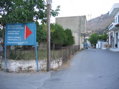
Figure 1: Sign to Kamares cave
Climb a concrete track for a few metres and then climb above it
through a blue gate. From here the path, marked by occasional
black-and-yellow E4 signs, ascends crossing and recrossing a
disused concrete water channel. The ascent is steep, past a couple
of tanks where you can get at the water flowing down the newer
metal pipe.
Eventually, the path crosses the top of a gorge coming to a
flat, wooded area at 1300m with two water troughs and a split in
the path at the second. The more direct route continues to the
left, while the route to the cave climbs up to the right.
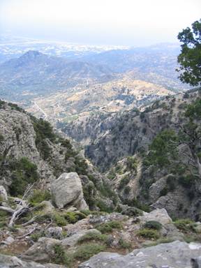
Figure 2: The view SSW past the distinctive Kartalos (718m) to
Agia Galini
The way up to the cave, about 1650m, is well marked with cairns.
The huge cave can be explored with care, down to its muddy depths
in complete darkness. The cave gives its name to a type of Minoan
pottery that was first found here by Italian archaeologists in
1893.
From the cave, descend and traverse around into another gorge by
a stone shelter. (We took an ill-advised alternative route, so are
not sure of the directions).
From here rise up a rocky slope above the main gorge, and then
contour into the valley, where the view opens out, and you come to
a trough and (the last) fresh water at the end of a track that
comes down the valley from the north.
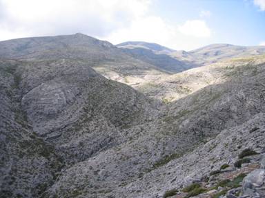
Figure 3: Looking North up the Mafiros
(Μαφιρος) valley past
Kotila
Follow this track a short way, then leave it to take a path to
the left along stone slabs that rejoins the track before a junction
near the river bed. Turn right up the valley, and turn off to the
left after a short way, heading towards some buildings. Before the
buildings, veer off to the left, and follow a couple of cairns, and
blue dots in a stream bed heading north and rejoining the track for
a short section. More cairns can be seen off to the right, and
eventually, near where this track ends at a large pit, cairns lead
to the right of a stone shelf. Here the tributary path joins the
main E4 at a sign, now vandalized, though to the East directions to
the Nidha roadhead (about 4km) and Kamares are painted on a small
cliff. Turn left, following the E4 poles and black-and-yellow
arrows. The path leads up a small valley (filled with snow in
several places in June), climbing steadily to reach a series of
three passes. The third finally rewards you with a view out to the
North East. From here climb West across the North face of Angathias
(Ανγαθιας 2424m).
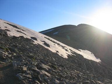
Figure 4: The path crossing a snow slope, and a top to the
summit (right)
Continue on the north side of the ridge, across two snowfields
(in June) and a small top, before the final ascent to Psiloritis,
(2456m) with the summit chapel of Timios Stavros
(Τιμιος
Σταυρος).
There are hollows for shelter on the South side of the slope,
and a sheltered spot for a tent North of the church, though the
chapel’s antechambers looks as though they are intended for
shelter.
From the summit, retrace your steps to the metal sign frame (the
sign is gone) and head over the small top (with and E4 pole) before
dropping off to the right (South) following arrows and poles that
are always visible (in good conditions). The path drops into a
south-facing valley before becoming well-defined, and follows the
valley to swing West. Descend West on a slope and enter a small
flat valley that steepens and then opens out. The E4 signs are now
nailed to trees, rather than being on metal posts. The path
descends to the North side of an obvious stone refuge (EOS
Rethymno’s Toupotos Prinos) with a large round second storey.
From the refuge a track leads North-South. One trail leads from
the SW corner of the refuge (presumably to Kouroutes) The E4 leads
off to the West about 20m north of the refuge. The trail
immediately recrosses the track which has switched back, but
continue almost due West following the indistinct trail, cairns and
E4 signs on trees over rough slopes. You will come to a sign to a
spring 300m south, but continue West down a steep rocky set of
manmade switchbacks. Continue following signs, as the route turns
South, and then West again along the rim of a large crater. Then
the path turns steeply down to the NW and eventually two cairns
presage a goat gate and the path emerges on a track. Follow this to
the North, always descending, to eventually come out on the
Fourfouras road, just south of the village.
All pages and photographs copyright © Andrew Senior 2005
Not to be reproduced or published without permission.