Hora Sfakion to Agia Roumeli via Anopoli
2 days 800m ascent/descent. Rough tracks. Some big steps up in
the gorge up to Anopoli.
The rough guide describes several sections of this walk, as well
as some other walks that connect with it. The text implies there
isn’t an off-road path to Anopoli from Hora Sfakion, though
their map shows the route taken here.
Start in Hora Sfakion (N35 12.012 E24 08.434), (The 9:30am
ferry from Paleochora arrives around 12noon). Climb out of the town
to the road that heads West. Just out of town (N35 12.171 E24
08.038), climb right up a narrow path which climbs steeply about 2
metres to reach a hillside where the path becomes a well-paved
stone mule track.
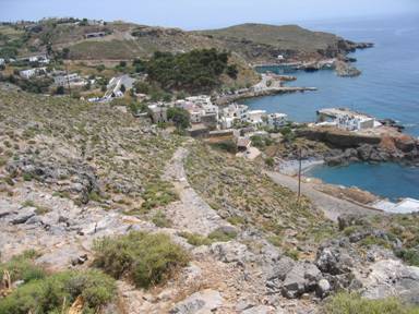
Figure 1: View back to Hora Sfakion
from the stone track
This track climbs West across the hillside, and joins with a
dirt track at a cairn. Turn left on the bulldozed track and follow
it until it turns sharp left at the edge of the gorge. (N35 12.292
E24 07.580). Here the path leaves the track, heading North on the
East side of the gorge, dropping into the valley on a built-up mule
track, shown in Figure 2.
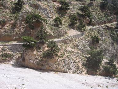
Figure 2: Looking back at the mule track descending the East side of the gorge. The new way down heads right from the trees.
After a short way, the path leads back left on a dirt slope
(show in Figure 2) down to the stream bed,since the mule track is
washed away a few metres further on. [At this point it should be
possible to follow the E4 back to the coast,but it wasn’t
apparent how to do this without following the gorge back to the
road]. Cross the floor of the gorge, going up slightly to join the
stone track again where it can be seen rising to the right of a
smaller gorge that joins from the West. (N35 12.457 E24 07.524).
Follow the track into the side gorge, where it is well-marked by
cairns. The Harms-Verlag map shows a trail above the gorge floor,
and there is some evidence for this, but the gorge floor is
passable and frequently cairned. A number of dead goats litter the
floor, and a few large steps up require the use of hands. The way
is clear and eventually leaves the gorge at (N35 12.530 E24 07.122)
but continues to follow the stream’s course to a goat fold or
ruin (N35 12.550 E24 06.854), soon followed by a building with
electric supply. Follow the dirt track West towards the radio masts
on the skyline, until, at a valley junction, it meets a track that
crosses the valley from the left servicing large, low, concrete
farm buildings to the left. Cross the valley on the dirt track and
pick up the line of the stone causeway as it zigzags up the hill
and then follows West just above the floor of the valley (which is
an alternative path). Soon it meets the road from Hora Sfakion
coming from the left, at a hairpin (N35 12.596 E24 06.276).
Immediately leave the road again and follow the valley/causeway
up WNW to a col near the radio masts. (N35 12.678 E24 06.101) and a
concrete road near them. Cross a fence/wall at a gate and head NW
along a track into the outskirts of Anopoli. The track has been
blocked in a few places, and eventually it is easier to walk on the
road, passing a tarverna before reaching the centre of town, a
roundabout (N35 13.079 E24 05.134) with a statue of Dhaskaloiannis
(a hero against the Turks in 1770) by taverna Platanias.
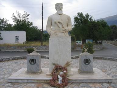
Figure 3: Statue of Dhaskaloiannis in Anopoli
Here one road leads SouthWest to Agia Katerina, and another NW
to Agia Ioannis. Follow this road towards Agia Ioannis, but where
the road turns right at a church, follow a small tarmac road down
the left side of the church. Follow it where it bends 90degrees
left, and continue on a stone track where it ends. This stone track
takes a short cut, and follows a bulldozed track for a while, but
can be followed across that track to join the road further on. (N35
13.373 E24 04.218). Then the road must be followed (although
another track leads right to descend into the gorge), passing the
road leading left to Liviniana at (N35 13.359 E24 03.966) A short
way on is the bridge across the impressive Aradhena gorge (N35
13.353 E24 03.738) whence the old track can be seen descending on
each side. The white church of Ag. can be seen on the West side.
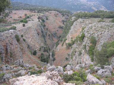
Figure 4: Tracks leading into each side of the Aradhena
Gorge
From here, follow the road a further 5km West, ascending slowly
to nearly 800m. Here you reach a gate across the road, at the edge
of Agios Ioannis. Immediately before the gate, a track leaves down
to the left to the larger of a pair of churches (N35 13.611 E24
01.258). Cross in front of this church towards a smaller church
(SW). A path leads down between the two, and continues (well
marked) to the top of the cliffs (N35 12.669 E24 01.279) high above
the E4 and the shore line. A well-built, if improbable causeway
descends the cliffs. Eventually this flattens out, heading NW
before joining the E4 (at N35 12.895 E24 00.514).
Continue 1200m along the E4 NW to get to Agios Pavlos church
(N35 13.374 E24 00.024). Continue along the clear E4, crossing the
Eligias Gorge (N35 13.792 E23 59.176) and coming to the river by
Agia Roumeli after 4km. A wooden bridge crosses the stream where
the E4 is signed and marked with cairns, and steps lead up the
embankment on the far side (N35 13.806 E23 57.838). Finally, walk
into town and the port of Agia Roumeli (N35 13.756 E23 57.619) past
plenty of tavernas.
All pages and photographs copyright © Andrew Senior 2005
Not to be reproduced or published without permission.